


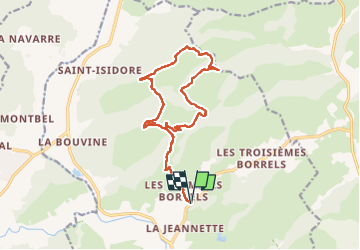
N3 1er Borrels

CHARONNET
User

Length
17 km

Max alt
295 m

Uphill gradient
550 m
Km-Effort
24 km

Min alt
26 m

Downhill gradient
550 m
Boucle
Yes
Creation date :
2025-04-10 06:14:12.73
Updated on :
2025-04-10 13:10:59.199
5h55
Difficulty : Very difficult

FREE GPS app for hiking
 SityTrail
IGN / Geographical institutes
SityTrail Plus
The world is yours!
About
Trail Walking of 17 km to be discovered at Provence-Alpes-Côte d'Azur, Var, Hyères. This trail is proposed by CHARONNET.
Photos


Positioning
Country:
France
Region :
Provence-Alpes-Côte d'Azur
Department/Province :
Var
Municipality :
Hyères
Location:
Unknown
Start:(Dec)
Start:(UTM)
269144 ; 4781918 (32T) N.
Comments