


Étape cinq du St Régis

Regisconraud
User
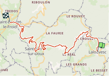

Length
21 km

Max alt
1207 m

Uphill gradient
698 m
Km-Effort
30 km

Min alt
831 m

Downhill gradient
666 m
Boucle
No
Creation date :
2025-04-10 07:43:18.494
Updated on :
2025-04-10 13:44:26.466
6h00
Difficulty : Very difficult

FREE GPS app for hiking
 SityTrail
IGN / Geographical institutes
SityTrail Plus
The world is yours!
About
Trail Walking of 21 km to be discovered at Auvergne-Rhône-Alpes, Ardèche, Lalouvesc. This trail is proposed by Regisconraud.
Positioning
Country:
France
Region :
Auvergne-Rhône-Alpes
Department/Province :
Ardèche
Municipality :
Lalouvesc
Location:
Unknown
Start:(Dec)
Start:(UTM)
620728 ; 4997396 (31T) N.
Comments