


Sabonnères fait 2025

pidjam
User

Length
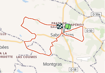
10.2 km

Max alt
327 m

Uphill gradient
208 m
Km-Effort
13 km

Min alt
214 m

Downhill gradient
210 m
Boucle
Yes
Creation date :
2025-04-10 12:21:08.414
Updated on :
2025-04-10 15:08:59.091
2h27
Difficulty : Medium

FREE GPS app for hiking
 SityTrail
IGN / Geographical institutes
SityTrail Plus
The world is yours!
About
Trail Walking of 10.2 km to be discovered at Occitania, Haute-Garonne, Sabonnères. This trail is proposed by pidjam.
Positioning
Country:
France
Region :
Occitania
Department/Province :
Haute-Garonne
Municipality :
Sabonnères
Location:
Unknown
Start:(Dec)
Start:(UTM)
343382 ; 4814445 (31T) N.
Comments