


2025-04-11_14h10m13_GTPBVW_Etape-16-Wéris-Chardeneux_2023-11-10

papyjose
User
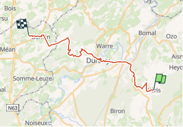

Length
21 km

Max alt
337 m

Uphill gradient
416 m
Km-Effort
26 km

Min alt
135 m

Downhill gradient
432 m
Boucle
No
Creation date :
2025-04-11 12:10:13.264
Updated on :
2025-04-11 12:10:14.689

FREE GPS app for hiking
 SityTrail
IGN / Geographical institutes
SityTrail Plus
The world is yours!
About
Trail of 21 km to be discovered at Wallonia, Luxembourg, Durbuy. This trail is proposed by papyjose.
Positioning
Country:
Belgium
Region :
Wallonia
Department/Province :
Luxembourg
Municipality :
Durbuy
Location:
Unknown
Start:(Dec)
Start:(UTM)
680200 ; 5578016 (31U) N.
Comments