


Étape six du St Régis

Regisconraud
User

Length
16.3 km

Max alt
1115 m

Uphill gradient
470 m
Km-Effort
24 km

Min alt
787 m

Downhill gradient
793 m
Boucle
No
Creation date :
2025-04-11 07:35:53.344
Updated on :
2025-04-11 12:45:44.205
5h09
Difficulty : Very difficult

FREE GPS app for hiking
 SityTrail
IGN / Geographical institutes
SityTrail Plus
The world is yours!
About
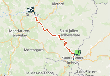
Trail Walking of 16.3 km to be discovered at Auvergne-Rhône-Alpes, Haute-Loire, Saint-Bonnet-le-Froid. This trail is proposed by Regisconraud.
Positioning
Country:
France
Region :
Auvergne-Rhône-Alpes
Department/Province :
Haute-Loire
Municipality :
Saint-Bonnet-le-Froid
Location:
Unknown
Start:(Dec)
Start:(UTM)
612866 ; 4999860 (31T) N.
Comments