


MN : CRESTET (Vaison la Romaine )

ARPF
User
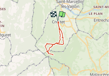

Length
11.2 km

Max alt
587 m

Uphill gradient
337 m
Km-Effort
15.7 km

Min alt
320 m

Downhill gradient
335 m
Boucle
Yes
Creation date :
2025-04-11 07:38:17.969
Updated on :
2025-04-16 05:46:02.141
2h30
Difficulty : Very easy

FREE GPS app for hiking
 SityTrail
IGN / Geographical institutes
SityTrail Plus
The world is yours!
About
Trail Nordic walking of 11.2 km to be discovered at Provence-Alpes-Côte d'Azur, Vaucluse, Crestet. This trail is proposed by ARPF.
Photos
 - Photo 1")
Positioning
Country:
France
Region :
Provence-Alpes-Côte d'Azur
Department/Province :
Vaucluse
Municipality :
Crestet
Location:
Unknown
Start:(Dec)
Start:(UTM)
666530 ; 4898048 (31T) N.
Comments