Trail Orienteering Saint-Dié-des-Vosges - MARCHE ORIENTATION : LA BURE - Photo

MARCHE ORIENTATION : LA BURE

 Balg1961
Balg1961

User

© OpenStreetMap contributors
Length
Length
7 km
Max alt
Max alt
657 m
Uphill gradient
Uphill gradient
278 m
Km-Effort
Km-Effort  
10.7 km
Min alt
Min alt
398 m
Downhill gradient
Downhill gradient
276 m
Boucle
Boucle
Yes
Creation date :
2025-04-12 04:49:08.537
Updated on :
2025-04-18 17:36:11.507

(0 Reviews)

Orienteering
Orienteering
2h20
Difficulty : Very easy

Scan this QR Code to open this trail in the SityTrail application

FREE GPS app for hiking

Logo SityTrail SityTrail

IGN / Geographical institutes

Download SityTrail from the App Store Download SityTrail from Google Play

Logo SityTrail SityTrail Plus

The world is yours!

Download SityTrail from the App Store Download SityTrail from Google Play Download SityTrail on Huawei AppGallery

About

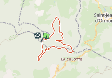
Trail Orienteering of 7 km to be discovered at Grand Est, Vosges, Saint-Dié-des-Vosges. This trail is proposed by Balg1961.

Description

Balise 1 : 48°19.0694 - 6°57.135 - > 200° - 750 m
Balise 2 : 48°19.3155 - 6°57.3945 - > 30° - 600 m
Balise 3 : 48°19.3622 - 6°57.9269 - > 90° - 680 m
Balise 4 : 48°19.2660 - 6°58.2845 - > 120° - 500 m
Balise 5 : 48°19.4008 - 6°58.0773 - > 320° - 360 m
Balise 6 : 48°19.5140 - 6°57.7311 - > 300° - 550 m
Balise 7 : 48°19.6545 - 6°57.7957 - > 20° - 380 m
Balise 8 : 48°20.0240 - 6°57.7290 - > 250° - 700 m
Balise 9 : 48°19.6782 - 6°57..6374 - > 200° - 680 m
Balise 10 : 48°19.4850 - 6°57.2470 - > 240° - 470 m

Echelle : 1/125000

Elevation profile

Positioning

Country:
France
Region :
Grand Est
Department/Province :
Vosges
Municipality :
Saint-Dié-des-Vosges
Location:
Unknown
Start:(UTM)
348332 ; 5354359 (32U) N.


Close
My subscriptions