


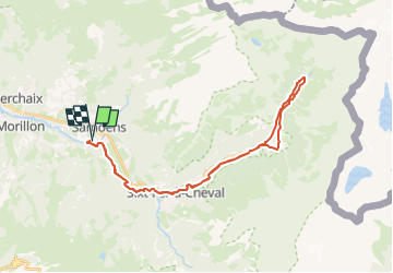
samoens-bout-du-monde

topolino
User

Length
33 km

Max alt
1055 m

Uphill gradient
747 m
Km-Effort
43 km

Min alt
695 m

Downhill gradient
747 m
Boucle
Yes
Creation date :
2025-04-12 08:53:39.228
Updated on :
2025-04-12 08:54:02.348
2h59
Difficulty : Very difficult

FREE GPS app for hiking
 SityTrail
IGN / Geographical institutes
SityTrail Plus
The world is yours!
About
Trail Mountain bike of 33 km to be discovered at Auvergne-Rhône-Alpes, Upper Savoy, Samoëns. This trail is proposed by topolino.
Description
Itinéraire facile au bord du Giffre permettant de découvrir le Bout du Monde depuis Samoëns.
Positioning
Country:
France
Region :
Auvergne-Rhône-Alpes
Department/Province :
Upper Savoy
Municipality :
Samoëns
Location:
Unknown
Start:(Dec)
Start:(UTM)
323939 ; 5105155 (32T) N.
Comments