


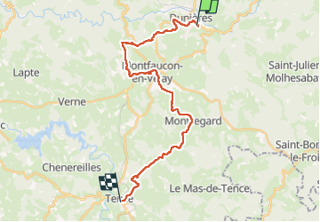
Étape sept du St Régis

Regisconraud
User

Length
26 km

Max alt
1005 m

Uphill gradient
650 m
Km-Effort
35 km

Min alt
787 m

Downhill gradient
591 m
Boucle
No
Creation date :
2025-04-12 06:46:55.975
Updated on :
2025-04-12 14:02:12.769
7h14
Difficulty : Very difficult

FREE GPS app for hiking
 SityTrail
IGN / Geographical institutes
SityTrail Plus
The world is yours!
About
Trail Walking of 26 km to be discovered at Auvergne-Rhône-Alpes, Haute-Loire, Dunières. This trail is proposed by Regisconraud.
Positioning
Country:
France
Region :
Auvergne-Rhône-Alpes
Department/Province :
Haute-Loire
Municipality :
Dunières
Location:
Unknown
Start:(Dec)
Start:(UTM)
605982 ; 5007325 (31T) N.
Comments