


Fougerolles... cerisiers... cool

PatriceCocuaud
User
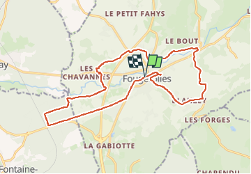

Length
18.7 km

Max alt
394 m

Uphill gradient
242 m
Km-Effort
22 km

Min alt
284 m

Downhill gradient
242 m
Boucle
Yes
Creation date :
2025-04-12 13:38:59.18
Updated on :
2025-04-12 15:25:07.991
1h45
Difficulty : Easy

FREE GPS app for hiking
 SityTrail
IGN / Geographical institutes
SityTrail Plus
The world is yours!
About
Trail Mountain bike of 18.7 km to be discovered at Bourgogne-Franche-Comté, Haute-Saône, Fougerolles-Saint-Valbert. This trail is proposed by PatriceCocuaud.
Positioning
Country:
France
Region :
Bourgogne-Franche-Comté
Department/Province :
Haute-Saône
Municipality :
Fougerolles-Saint-Valbert
Location:
Unknown
Start:(Dec)
Start:(UTM)
305924 ; 5306934 (32T) N.
Comments