


Cassis les calanques

FrancisM.
User
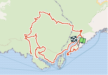

Length
18.5 km

Max alt
209 m

Uphill gradient
629 m
Km-Effort
27 km

Min alt
3 m

Downhill gradient
613 m
Boucle
Yes
Creation date :
2025-04-13 07:18:20.164
Updated on :
2025-04-13 13:30:10.462
5h29
Difficulty : Very difficult

FREE GPS app for hiking
 SityTrail
IGN / Geographical institutes
SityTrail Plus
The world is yours!
About
Trail Walking of 18.5 km to be discovered at Provence-Alpes-Côte d'Azur, Bouches-du-Rhône, Cassis. This trail is proposed by FrancisM..
Positioning
Country:
France
Region :
Provence-Alpes-Côte d'Azur
Department/Province :
Bouches-du-Rhône
Municipality :
Cassis
Location:
Unknown
Start:(Dec)
Start:(UTM)
704796 ; 4786862 (31T) N.
Comments