


St Chéron -pont de bois

Auger91
User
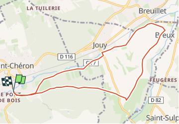

Length
9.8 km

Max alt
120 m

Uphill gradient
120 m
Km-Effort
11.4 km

Min alt
58 m

Downhill gradient
116 m
Boucle
Yes
Creation date :
2025-04-13 16:11:57.623
Updated on :
2025-04-13 16:18:59.91
2h35
Difficulty : Medium

FREE GPS app for hiking
 SityTrail
IGN / Geographical institutes
SityTrail Plus
The world is yours!
About
Trail Walking of 9.8 km to be discovered at Ile-de-France, Essonne, Saint-Chéron. This trail is proposed by Auger91.
Positioning
Country:
France
Region :
Ile-de-France
Department/Province :
Essonne
Municipality :
Saint-Chéron
Location:
Unknown
Start:(Dec)
Start:(UTM)
435418 ; 5377641 (31U) N.
Comments