


Dan47 - 2025 Villers la ville (bis) .

istadaniel
User
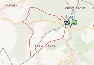

Length
8.3 km

Max alt
153 m

Uphill gradient
130 m
Km-Effort
10 km

Min alt
95 m

Downhill gradient
130 m
Boucle
Yes
Creation date :
2025-04-14 07:58:10.941
Updated on :
2025-04-16 06:52:59.399
2h16
Difficulty : Medium

FREE GPS app for hiking
 SityTrail
IGN / Geographical institutes
SityTrail Plus
The world is yours!
About
Trail Walking of 8.3 km to be discovered at Wallonia, Walloon Brabant, Villers-la-Ville. This trail is proposed by istadaniel.
Positioning
Country:
Belgium
Region :
Wallonia
Department/Province :
Walloon Brabant
Municipality :
Villers-la-Ville
Location:
Villers-la-Ville
Start:(Dec)
Start:(UTM)
608309 ; 5605230 (31U) N.
Comments