


fin trace Claudine 13 04 2025

pablo92
User
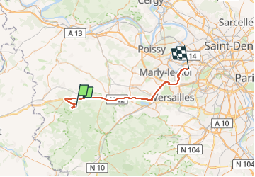

Length
50 km

Max alt
193 m

Uphill gradient
459 m
Km-Effort
57 km

Min alt
20 m

Downhill gradient
570 m
Boucle
No
Creation date :
2025-04-13 12:14:54.6
Updated on :
2025-04-14 09:01:20.766
20h45
Difficulty : Very difficult

FREE GPS app for hiking
 SityTrail
IGN / Geographical institutes
SityTrail Plus
The world is yours!
About
Trail Walking of 50 km to be discovered at Ile-de-France, Yvelines, Grosrouvre. This trail is proposed by pablo92.
Positioning
Country:
France
Region :
Ile-de-France
Department/Province :
Yvelines
Municipality :
Grosrouvre
Location:
Unknown
Start:(Dec)
Start:(UTM)
408081 ; 5403407 (31U) N.
Comments