
Compostelle 08 - Espalion -> Estaing

uru2010
User
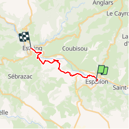

Length
13.8 km

Max alt
491 m

Uphill gradient
303 m
Km-Effort
17.9 km

Min alt
312 m

Downhill gradient
327 m
Boucle
No
Creation date :
2018-06-12 00:00:00.0
Updated on :
2018-06-12 00:00:00.0
3h53
Difficulty : Easy

FREE GPS app for hiking
 SityTrail
IGN / Geographical institutes
SityTrail Plus
The world is yours!
About
Trail Walking of 13.8 km to be discovered at Occitania, Aveyron, Espalion. This trail is proposed by uru2010.
Description
Chemin de St Jacques de Compostelle
Espalion -> Estaing
Photos

Positioning
Country:
France
Region :
Occitania
Department/Province :
Aveyron
Municipality :
Espalion
Location:
Unknown
Start:(Dec)
Start:(UTM)
480951 ; 4929780 (31T) N.
Comments