


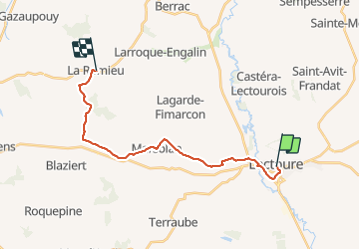
Compostelle 22 - Lectoure -> La Romieu

uru2010
User

Length
19.8 km

Max alt
219 m

Uphill gradient
364 m
Km-Effort
25 km

Min alt
75 m

Downhill gradient
359 m
Boucle
No
Creation date :
2018-06-12 00:00:00.0
Updated on :
2018-06-12 00:00:00.0
5h26
Difficulty : Easy

FREE GPS app for hiking
 SityTrail
IGN / Geographical institutes
SityTrail Plus
The world is yours!
About
Trail Walking of 19.8 km to be discovered at Occitania, Gers, Lectoure. This trail is proposed by uru2010.
Description
Chemin de St Jacques de Compostelle
Lectoure - La Romieu
Positioning
Country:
France
Region :
Occitania
Department/Province :
Gers
Municipality :
Lectoure
Location:
Unknown
Start:(Dec)
Start:(UTM)
309130 ; 4867295 (31T) N.
Comments