


St Laurent en Beaumont - le Signal de St Michell

rolland-a
User
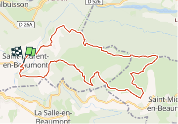

Length
12.4 km

Max alt
1488 m

Uphill gradient
657 m
Km-Effort
21 km

Min alt
901 m

Downhill gradient
658 m
Boucle
Yes
Creation date :
2025-04-14 22:31:45.513
Updated on :
2025-04-14 22:37:26.668
4h49
Difficulty : Very difficult

FREE GPS app for hiking
 SityTrail
IGN / Geographical institutes
SityTrail Plus
The world is yours!
About
Trail Walking of 12.4 km to be discovered at Auvergne-Rhône-Alpes, Isère, Saint-Laurent-en-Beaumont. This trail is proposed by rolland-a.
Positioning
Country:
France
Region :
Auvergne-Rhône-Alpes
Department/Province :
Isère
Municipality :
Saint-Laurent-en-Beaumont
Location:
Unknown
Start:(Dec)
Start:(UTM)
725028 ; 4973283 (31T) N.
Comments