


Champs Elysées à Joinville-le-Pont

uru2010
User
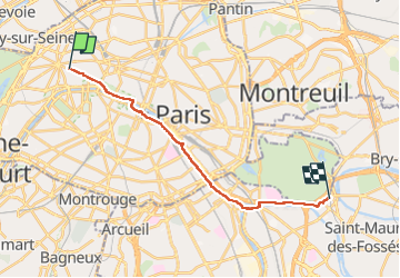

Length
17 km

Max alt
67 m

Uphill gradient
206 m
Km-Effort
19.8 km

Min alt
22 m

Downhill gradient
204 m
Boucle
No
Creation date :
2015-07-08 00:00:00.0
Updated on :
2015-07-08 00:00:00.0
3h55
Difficulty : Very easy

FREE GPS app for hiking
 SityTrail
IGN / Geographical institutes
SityTrail Plus
The world is yours!
About
Trail Walking of 17 km to be discovered at Ile-de-France, Paris, Paris. This trail is proposed by uru2010.
Description
Parcours piéton sympa le long de la Seine puis de la Marne, jusqu'au RER de Joinville-le-Pont.
Positioning
Country:
France
Region :
Ile-de-France
Department/Province :
Paris
Municipality :
Paris
Location:
8th Arrondissement of Paris
Start:(Dec)
Start:(UTM)
448851 ; 5413414 (31U) N.
Comments