


Bira fouché Pyrénées champs vert

sameja
User
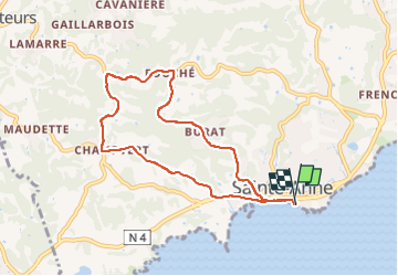

Length
10.5 km

Max alt
115 m

Uphill gradient
211 m
Km-Effort
13.3 km

Min alt
0 m

Downhill gradient
210 m
Boucle
Yes
Creation date :
2025-04-15 09:19:18.0
Updated on :
2025-04-15 13:21:09.782
1h21
Difficulty : Medium

FREE GPS app for hiking
 SityTrail
IGN / Geographical institutes
SityTrail Plus
The world is yours!
About
Trail Trail of 10.5 km to be discovered at Guadeloupe, Unknown, Sainte-Anne. This trail is proposed by sameja.
Description
La boucle de st Anne
Positioning
Country:
France
Region :
Guadeloupe
Department/Province :
Unknown
Municipality :
Sainte-Anne
Location:
Unknown
Start:(Dec)
Start:(UTM)
672714 ; 1794372 (20Q) N.
Comments