


Bourgneuf en retz _ Les éoliennes

neoroll44
User

Length
18.6 km

Max alt
38 m

Uphill gradient
108 m
Km-Effort
20 km

Min alt
0 m

Downhill gradient
105 m
Boucle
Yes
Creation date :
2025-04-15 16:47:04.949
Updated on :
2025-04-16 16:23:22.49
5h00
Difficulty : Medium
2h00
Difficulty : Easy

FREE GPS app for hiking
 SityTrail
IGN / Geographical institutes
SityTrail Plus
The world is yours!
About
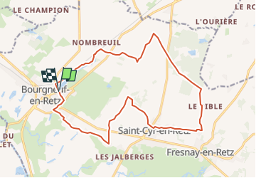
Trail Walking of 18.6 km to be discovered at Pays de la Loire, Loire-Atlantique, Villeneuve-en-Retz. This trail is proposed by neoroll44.
Description
Depuis l'étang du moulin, boucle par le champ éolien et le bourg de St-Cyr en Retz par des petires routes et des chemins.
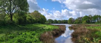
Photos


Positioning
Country:
France
Region :
Pays de la Loire
Department/Province :
Loire-Atlantique
Municipality :
Villeneuve-en-Retz
Location:
Bourgneuf-en-Retz
Start:(Dec)
Start:(UTM)
580126 ; 5210749 (30T) N.
Comments