


téléthon 2024

JamesVautier
User

Length
8.7 km

Max alt
137 m

Uphill gradient
136 m
Km-Effort
10.5 km

Min alt
31 m

Downhill gradient
136 m
Boucle
Yes
Creation date :
2025-04-15 11:37:54.095
Updated on :
2025-04-15 19:04:50.863
2h25
Difficulty : Easy

FREE GPS app for hiking
 SityTrail
IGN / Geographical institutes
SityTrail Plus
The world is yours!
About
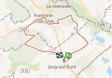
Trail Walking of 8.7 km to be discovered at Normandy, Eure, Jouy-sur-Eure. This trail is proposed by JamesVautier.
Photos


Positioning
Country:
France
Region :
Normandy
Department/Province :
Eure
Municipality :
Jouy-sur-Eure
Location:
Unknown
Start:(Dec)
Start:(UTM)
375901 ; 5434420 (31U) N.
Comments