


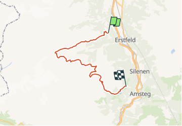
Sunnig Täler Höhenweg + Panoramaweg

alternatives-wandern
User

Length
20 km

Max alt
2402 m

Uphill gradient
1915 m
Km-Effort
45 km

Min alt
1070 m

Downhill gradient
1713 m
Boucle
No
Creation date :
2014-12-10 00:00:00.0
Updated on :
2014-12-10 00:00:00.0
--
Difficulty : Unknown

FREE GPS app for hiking
 SityTrail
IGN / Geographical institutes
SityTrail Plus
The world is yours!
About
Trail Other activity of 20 km to be discovered at Uri, Unknown, Erstfeld. This trail is proposed by alternatives-wandern.
Description
Detailbeschreibung siehe :
www.alternatives-wandern.ch/touren/trekking/sunnigtaeler.htm
Positioning
Country:
Switzerland
Region :
Uri
Department/Province :
Unknown
Municipality :
Erstfeld
Location:
Unknown
Start:(Dec)
Start:(UTM)
471553 ; 5186061 (32T) N.
Comments