


Cornimont- jeudi 13/05/25

chantalwaltzer
User
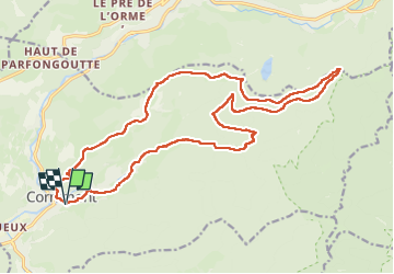

Length
23 km

Max alt
1097 m

Uphill gradient
735 m
Km-Effort
32 km

Min alt
511 m

Downhill gradient
735 m
Boucle
Yes
Creation date :
2025-04-16 08:06:55.0
Updated on :
2025-04-16 16:20:21.239
7h42
Difficulty : Very difficult

FREE GPS app for hiking
 SityTrail
IGN / Geographical institutes
SityTrail Plus
The world is yours!
About
Trail Walking of 23 km to be discovered at Grand Est, Vosges, Cornimont. This trail is proposed by chantalwaltzer.
Description
à refaire
Positioning
Country:
France
Region :
Grand Est
Department/Province :
Vosges
Municipality :
Cornimont
Location:
Unknown
Start:(Dec)
Start:(UTM)
338866 ; 5314363 (32T) N.
Comments