


l'oustalet - clape

vertygo
User
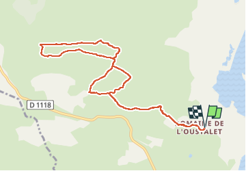

Length
11.4 km

Max alt
115 m

Uphill gradient
167 m
Km-Effort
13.7 km

Min alt
2 m

Downhill gradient
167 m
Boucle
Yes
Creation date :
2025-04-17 06:52:17.684
Updated on :
2025-04-17 10:00:01.741
3h07
Difficulty : Difficult

FREE GPS app for hiking
 SityTrail
IGN / Geographical institutes
SityTrail Plus
The world is yours!
About
Trail Walking of 11.4 km to be discovered at Occitania, Aude, Fleury. This trail is proposed by vertygo.
Positioning
Country:
France
Region :
Occitania
Department/Province :
Aude
Municipality :
Fleury
Location:
Unknown
Start:(Dec)
Start:(UTM)
515483 ; 4782772 (31T) N.
Comments