


Gr34 Abbaye de Beauport

taguette
User
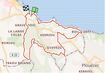

Length
11.9 km

Max alt
77 m

Uphill gradient
197 m
Km-Effort
14.5 km

Min alt
3 m

Downhill gradient
198 m
Boucle
Yes
Creation date :
2025-04-16 06:49:19.945
Updated on :
2025-04-17 14:44:20.745
3h28
Difficulty : Difficult

FREE GPS app for hiking
 SityTrail
IGN / Geographical institutes
SityTrail Plus
The world is yours!
About
Trail Walking of 11.9 km to be discovered at Brittany, Côtes-d'Armor, Paimpol. This trail is proposed by taguette.
Positioning
Country:
France
Region :
Brittany
Department/Province :
Côtes-d'Armor
Municipality :
Paimpol
Location:
Unknown
Start:(Dec)
Start:(UTM)
498484 ; 5401734 (30U) N.
Comments