


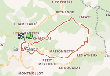
Saint-Heant du 18/04/2025

VANDERPUTTENMi
User GUIDE

Length
9.4 km

Max alt
873 m

Uphill gradient
281 m
Km-Effort
13.2 km

Min alt
665 m

Downhill gradient
281 m
Boucle
Yes
Creation date :
2025-04-18 07:33:44.308
Updated on :
2025-04-18 10:39:40.888
2h21
Difficulty : Difficult

FREE GPS app for hiking
 SityTrail
IGN / Geographical institutes
SityTrail Plus
The world is yours!
About
Trail Walking of 9.4 km to be discovered at Auvergne-Rhône-Alpes, Loire, Saint-Héand. This trail is proposed by VANDERPUTTENMi.
Description
une boucle avec de belles vues.
Photos


Positioning
Country:
France
Region :
Auvergne-Rhône-Alpes
Department/Province :
Loire
Municipality :
Saint-Héand
Location:
Unknown
Start:(Dec)
Start:(UTM)
607368 ; 5042989 (31T) N.
Comments