


teŕ

ROBERT-MICHEL
User
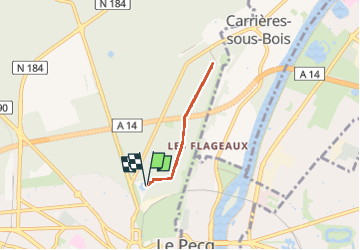

Length
3.9 km

Max alt
88 m

Uphill gradient
38 m
Km-Effort
4.4 km

Min alt
74 m

Downhill gradient
38 m
Boucle
Yes
Creation date :
2025-04-19 08:38:47.411
Updated on :
2025-04-19 09:50:31.626
1h11
Difficulty : Easy

FREE GPS app for hiking
 SityTrail
IGN / Geographical institutes
SityTrail Plus
The world is yours!
About
Trail Walking of 3.9 km to be discovered at Ile-de-France, Yvelines, Saint-Germain-en-Laye. This trail is proposed by ROBERT-MICHEL.
Description
terr11
Positioning
Country:
France
Region :
Ile-de-France
Department/Province :
Yvelines
Municipality :
Saint-Germain-en-Laye
Location:
Saint-Germain-en-Laye
Start:(Dec)
Start:(UTM)
433761 ; 5417241 (31U) N.
Comments