La Cance

Vedett26
User

Length
15 km

Max alt
386 m

Uphill gradient
399 m
Km-Effort
20 km

Min alt
238 m

Downhill gradient
399 m
Boucle
Yes
Creation date :
2025-04-19 16:44:47.535
Updated on :
2025-04-19 16:45:33.477
4h37
Difficulty : Medium

FREE GPS app for hiking
 SityTrail
IGN / Geographical institutes
SityTrail Plus
The world is yours!
About
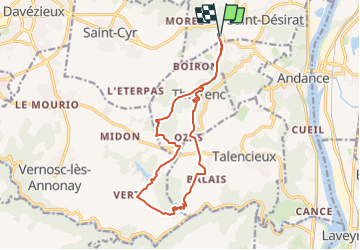
Trail Walking of 15 km to be discovered at Auvergne-Rhône-Alpes, Ardèche, Saint-Désirat. This trail is proposed by Vedett26.
Positioning
Country:
France
Region :
Auvergne-Rhône-Alpes
Department/Province :
Ardèche
Municipality :
Saint-Désirat
Location:
Unknown
Start:(Dec)
Start:(UTM)
638901 ; 5012330 (31T) N.
Comments