


Laguiole

georghinio
User
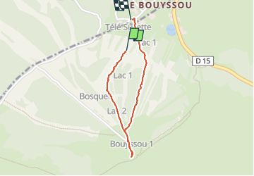

Length
1.3 km

Max alt
1402 m

Uphill gradient
76 m
Km-Effort
2.4 km

Min alt
1307 m

Downhill gradient
93 m
Boucle
Yes
Creation date :
2025-04-20 08:45:00.0
Updated on :
2025-04-20 09:25:44.848

FREE GPS app for hiking
 SityTrail
IGN / Geographical institutes
SityTrail Plus
The world is yours!
About
Trail of 1.3 km to be discovered at Occitania, Aveyron, Curières. This trail is proposed by georghinio.
Positioning
Country:
France
Region :
Occitania
Department/Province :
Aveyron
Municipality :
Curières
Location:
Unknown
Start:(Dec)
Start:(UTM)
494063 ; 4946346 (31T) N.
Comments