


Rif Didier 20042025 faite.

dblix
User
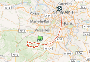

Length
76 km

Max alt
183 m

Uphill gradient
1251 m
Km-Effort
93 km

Min alt
30 m

Downhill gradient
1294 m
Boucle
No
Creation date :
2025-04-20 07:11:11.0
Updated on :
2025-04-20 21:00:40.534
8h28
Difficulty : Very difficult

FREE GPS app for hiking
 SityTrail
IGN / Geographical institutes
SityTrail Plus
The world is yours!
About
Trail Walking of 76 km to be discovered at Ile-de-France, Yvelines, Saint-Rémy-lès-Chevreuse. This trail is proposed by dblix.
Positioning
Country:
France
Region :
Ile-de-France
Department/Province :
Yvelines
Municipality :
Saint-Rémy-lès-Chevreuse
Location:
Unknown
Start:(Dec)
Start:(UTM)
431614 ; 5394838 (31U) N.
Comments