


Lac de filhet, Montauriol, casteras

loic09
User
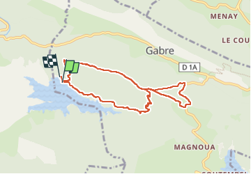

Length
8.1 km

Max alt
500 m

Uphill gradient
234 m
Km-Effort
11.2 km

Min alt
324 m

Downhill gradient
229 m
Boucle
Yes
Creation date :
2025-04-21 07:20:43.166
Updated on :
2025-04-21 09:53:18.216
2h17
Difficulty : Medium

FREE GPS app for hiking
 SityTrail
IGN / Geographical institutes
SityTrail Plus
The world is yours!
About
Trail Walking of 8.1 km to be discovered at Occitania, Ariège, Gabre. This trail is proposed by loic09.
Positioning
Country:
France
Region :
Occitania
Department/Province :
Ariège
Municipality :
Gabre
Location:
Unknown
Start:(Dec)
Start:(UTM)
369212 ; 4769784 (31T) N.
Comments