


Peyrolles

darranger
User
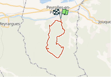

Length
12.2 km

Max alt
454 m

Uphill gradient
322 m
Km-Effort
16.5 km

Min alt
248 m

Downhill gradient
323 m
Boucle
Yes
Creation date :
2025-04-21 08:37:49.87
Updated on :
2025-04-21 14:46:11.277
3h52
Difficulty : Difficult

FREE GPS app for hiking
 SityTrail
IGN / Geographical institutes
SityTrail Plus
The world is yours!
About
Trail Walking of 12.2 km to be discovered at Provence-Alpes-Côte d'Azur, Bouches-du-Rhône, Peyrolles-en-Provence. This trail is proposed by darranger.
Positioning
Country:
France
Region :
Provence-Alpes-Côte d'Azur
Department/Province :
Bouches-du-Rhône
Municipality :
Peyrolles-en-Provence
Location:
Unknown
Start:(Dec)
Start:(UTM)
708638 ; 4835042 (31T) N.
Comments