


st maxime

mcterret
User
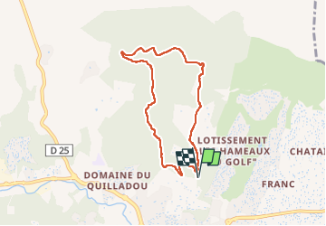

Length
7.1 km

Max alt
329 m

Uphill gradient
281 m
Km-Effort
10.9 km

Min alt
50 m

Downhill gradient
281 m
Boucle
Yes
Creation date :
2025-04-21 12:37:23.413
Updated on :
2025-04-21 16:22:44.973
3h44
Difficulty : Medium

FREE GPS app for hiking
 SityTrail
IGN / Geographical institutes
SityTrail Plus
The world is yours!
About
Trail Walking of 7.1 km to be discovered at Provence-Alpes-Côte d'Azur, Var, Sainte-Maxime. This trail is proposed by mcterret.
Positioning
Country:
France
Region :
Provence-Alpes-Côte d'Azur
Department/Province :
Var
Municipality :
Sainte-Maxime
Location:
Unknown
Start:(Dec)
Start:(UTM)
308498 ; 4799922 (32T) N.
Comments