


Anderlues Buvrinnes 21 04 25

andremusin
User
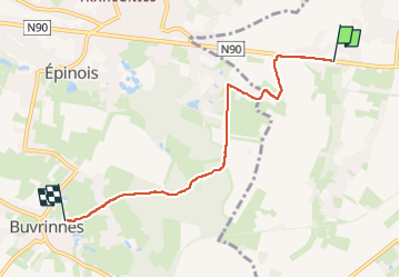

Length
4.7 km

Max alt
199 m

Uphill gradient
62 m
Km-Effort
5.6 km

Min alt
152 m

Downhill gradient
75 m
Boucle
No
Creation date :
2025-04-21 15:24:40.337
Updated on :
2025-04-21 16:30:49.345
1h02
Difficulty : Easy

FREE GPS app for hiking
 SityTrail
IGN / Geographical institutes
SityTrail Plus
The world is yours!
About
Trail Walking of 4.7 km to be discovered at Wallonia, Hainaut, Anderlues. This trail is proposed by andremusin.
Positioning
Country:
Belgium
Region :
Wallonia
Department/Province :
Hainaut
Municipality :
Anderlues
Location:
Unknown
Start:(Dec)
Start:(UTM)
588822 ; 5584518 (31U) N.
Comments