


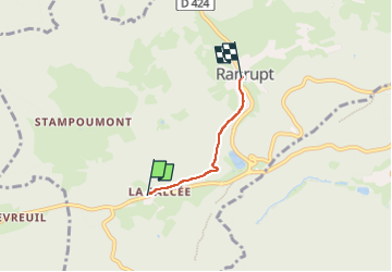
La Salcée -Ranrupt

AgnesPollux
User

Length
2.2 km

Max alt
586 m

Uphill gradient
22 m
Km-Effort
2.7 km

Min alt
511 m

Downhill gradient
76 m
Boucle
No
Creation date :
2025-04-22 06:24:44.314
Updated on :
2025-04-22 06:54:41.242
29m
Difficulty : Easy

FREE GPS app for hiking
 SityTrail
IGN / Geographical institutes
SityTrail Plus
The world is yours!
About
Trail Walking of 2.2 km to be discovered at Grand Est, Bas-Rhin, Ranrupt. This trail is proposed by AgnesPollux.
Positioning
Country:
France
Region :
Grand Est
Department/Province :
Bas-Rhin
Municipality :
Ranrupt
Location:
Unknown
Start:(Dec)
Start:(UTM)
365447 ; 5358053 (32U) N.
Comments