


gastadou2

orsel
User GUIDE
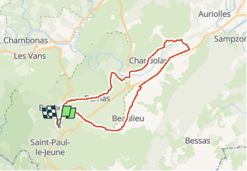

Length
33 km

Max alt
237 m

Uphill gradient
336 m
Km-Effort
38 km

Min alt
104 m

Downhill gradient
336 m
Boucle
Yes
Creation date :
2025-04-21 07:42:55.01
Updated on :
2025-04-22 09:45:48.266
2h04
Difficulty : Difficult

FREE GPS app for hiking
 SityTrail
IGN / Geographical institutes
SityTrail Plus
The world is yours!
About
Trail Mountain bike of 33 km to be discovered at Auvergne-Rhône-Alpes, Ardèche, Banne. This trail is proposed by orsel.
Positioning
Country:
France
Region :
Auvergne-Rhône-Alpes
Department/Province :
Ardèche
Municipality :
Banne
Location:
Unknown
Start:(Dec)
Start:(UTM)
592701 ; 4911840 (31T) N.
Comments