


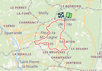
Saint Bonnet de Cray

Pierre Burthier
User

Length
12 km

Max alt
448 m

Uphill gradient
266 m
Km-Effort
15.6 km

Min alt
322 m

Downhill gradient
274 m
Boucle
Yes
Creation date :
2025-04-23 09:16:20.514
Updated on :
2025-05-02 12:16:56.318
3h32
Difficulty : Difficult

FREE GPS app for hiking
 SityTrail
IGN / Geographical institutes
SityTrail Plus
The world is yours!
About
Trail Walking of 12 km to be discovered at Bourgogne-Franche-Comté, Saône-et-Loire, Saint-Bonnet-de-Cray. This trail is proposed by Pierre Burthier.
Description
12 km
Positioning
Country:
France
Region :
Bourgogne-Franche-Comté
Department/Province :
Saône-et-Loire
Municipality :
Saint-Bonnet-de-Cray
Location:
Unknown
Start:(Dec)
Start:(UTM)
587914 ; 5118557 (31T) N.
Comments