


SityTrail - Jouars-St-Remy jour

Rando MLC
User
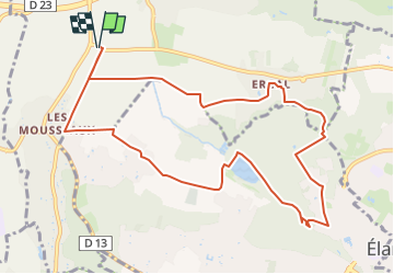

Length
10.7 km

Max alt
178 m

Uphill gradient
141 m
Km-Effort
12.6 km

Min alt
88 m

Downhill gradient
141 m
Boucle
Yes
Creation date :
2025-04-23 12:06:26.966
Updated on :
2025-04-24 14:16:43.189
2h51
Difficulty : Difficult

FREE GPS app for hiking
 SityTrail
IGN / Geographical institutes
SityTrail Plus
The world is yours!
About
Trail Walking of 10.7 km to be discovered at Ile-de-France, Yvelines, Jouars-Pontchartrain. This trail is proposed by Rando MLC.
Description
track
Positioning
Country:
France
Region :
Ile-de-France
Department/Province :
Yvelines
Municipality :
Jouars-Pontchartrain
Location:
Unknown
Start:(Dec)
Start:(UTM)
419288 ; 5404580 (31U) N.
Comments