Trail Walking Châtillon-en-Diois - Chatillon en Diois combe de baïn, source de l'adoux et sentier de découverte - Photo

Chatillon en Diois combe de baïn, source de l'adoux et sentier de découverte

© OpenStreetMap contributors
Length
Length
17.7 km
Max alt
Max alt
1184 m
Uphill gradient
Uphill gradient
886 m
Km-Effort
Km-Effort  
29 km
Min alt
Min alt
562 m
Downhill gradient
Downhill gradient
885 m
Boucle
Boucle
Yes
Creation date :
2025-04-24 06:45:50.91
Updated on :
2025-04-26 15:51:22.13

(0 Reviews)

Walking
Walking
6h42
Difficulty : Difficult

Scan this QR Code to open this trail in the SityTrail application

FREE GPS app for hiking

Logo SityTrail SityTrail

IGN / Geographical institutes

Download SityTrail from the App Store Download SityTrail from Google Play

Logo SityTrail SityTrail Plus

The world is yours!

Download SityTrail from the App Store Download SityTrail from Google Play Download SityTrail on Huawei AppGallery

About

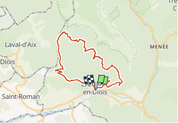
Trail Walking of 17.7 km to be discovered at Auvergne-Rhône-Alpes, Drôme, Châtillon-en-Diois. This trail is proposed by Danielle07.

Description

Très belle randonnée, passage en balcon très agréable. A noter toutefois que le sentier longe des dévers et falaises où il faut être prudent !
La source et la cascade de l'Adoux sont impressionnantes. Les panneaux explicatifs sont très instructifs sur la vie dans ce vallon.

Elevation profile

Positioning

Country:
France
Region :
Auvergne-Rhône-Alpes
Department/Province :
Drôme
Municipality :
Châtillon-en-Diois
Location:
Châtillon-en-Diois
Start:(UTM)
696983 ; 4951950 (31T) N.


Close
My subscriptions