


annecy

yvesconnes
User
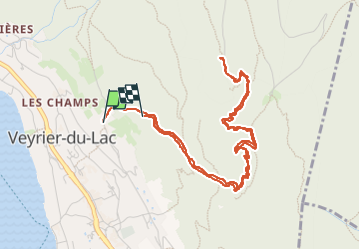

Length
5.9 km

Max alt
1252 m

Uphill gradient
672 m
Km-Effort
14.5 km

Min alt
569 m

Downhill gradient
558 m
Boucle
No
Creation date :
2025-04-24 09:30:46.553
Updated on :
2025-04-24 14:28:48.901
3h30
Difficulty : Difficult

FREE GPS app for hiking
 SityTrail
IGN / Geographical institutes
SityTrail Plus
The world is yours!
About
Trail Walking of 5.9 km to be discovered at Auvergne-Rhône-Alpes, Upper Savoy, Veyrier-du-Lac. This trail is proposed by yvesconnes.
Description
lac avec Cécile
Positioning
Country:
France
Region :
Auvergne-Rhône-Alpes
Department/Province :
Upper Savoy
Municipality :
Veyrier-du-Lac
Location:
Unknown
Start:(Dec)
Start:(UTM)
281123 ; 5085486 (32T) N.
Comments