


les crêtes de camps la source

bernir
User
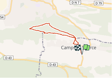

Length
7.2 km

Max alt
435 m

Uphill gradient
219 m
Km-Effort
10.1 km

Min alt
268 m

Downhill gradient
220 m
Boucle
Yes
Creation date :
2025-04-24 08:02:50.675
Updated on :
2025-04-25 08:14:32.729
4h35
Difficulty : Easy

FREE GPS app for hiking
 SityTrail
IGN / Geographical institutes
SityTrail Plus
The world is yours!
About
Trail Walking of 7.2 km to be discovered at Provence-Alpes-Côte d'Azur, Var, Camps-la-Source. This trail is proposed by bernir.
Positioning
Country:
France
Region :
Provence-Alpes-Côte d'Azur
Department/Province :
Var
Municipality :
Camps-la-Source
Location:
Unknown
Start:(Dec)
Start:(UTM)
264914 ; 4807364 (32T) N.
Comments