


20250425 Soirs

Jeanclaudebic
User
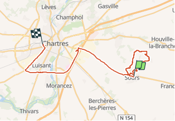

Length
31 km

Max alt
161 m

Uphill gradient
175 m
Km-Effort
33 km

Min alt
126 m

Downhill gradient
172 m
Boucle
No
Creation date :
2025-04-25 11:30:52.055
Updated on :
2025-04-25 18:39:48.52
7h06
Difficulty : Very difficult

FREE GPS app for hiking
 SityTrail
IGN / Geographical institutes
SityTrail Plus
The world is yours!
About
Trail Walking of 31 km to be discovered at Centre-Loire Valley, Eure-et-Loir, Sours. This trail is proposed by Jeanclaudebic.
Positioning
Country:
France
Region :
Centre-Loire Valley
Department/Province :
Eure-et-Loir
Municipality :
Sours
Location:
Unknown
Start:(Dec)
Start:(UTM)
396362 ; 5363142 (31U) N.
Comments