


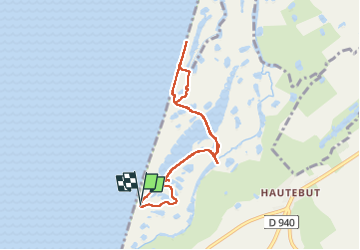
hable d'Ault
© OpenStreetMap contributors


1h59
Difficulty : Medium


Length
7.2 km
Max alt
6 m
Uphill gradient
28 m
Km-Effort
7.6 km
Min alt
-1 m
Downhill gradient
27 m
Boucle
Yes
Creation date :
2025-04-26 08:24:51.307
Updated on :
2025-04-26 12:27:23.847
1h59
Difficulty : Medium
FREE GPS app for hiking
 SityTrail
IGN / Geographical institutes
SityTrail Plus
The world is yours!
About
Trail Walking of 7.2 km to be discovered at Hauts-de-France, Somme, Woignarue. This trail is proposed by damerenvielle@gmail.com.
Positioning
Country:
France
Region :
Hauts-de-France
Department/Province :
Somme
Municipality :
Woignarue
Location:
Unknown
Start:(Dec)
Start:(UTM)
390059 ; 5553527 (31U) N.
Comments