


cullera fait 2025

pidjam
User
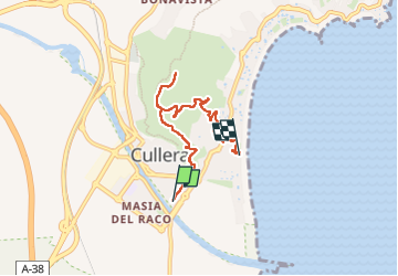

Length
6.5 km

Max alt
201 m

Uphill gradient
227 m
Km-Effort
9.4 km

Min alt
0 m

Downhill gradient
215 m
Boucle
No
Creation date :
2025-04-26 11:58:29.337
Updated on :
2025-04-26 14:23:50.748
1h54
Difficulty : Medium

FREE GPS app for hiking
 SityTrail
IGN / Geographical institutes
SityTrail Plus
The world is yours!
About
Trail Walking of 6.5 km to be discovered at Valencian Community, Valencia, Cullera. This trail is proposed by pidjam.
Positioning
Country:
Spain
Region :
Valencian Community
Department/Province :
Valencia
Municipality :
Cullera
Location:
Unknown
Start:(Dec)
Start:(UTM)
737426 ; 4338022 (30S) N.
Comments