


Randonnée le cap roux

mb83serre
User GUIDE
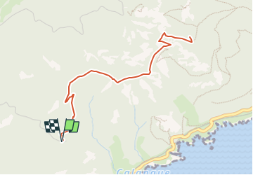

Length
5.4 km

Max alt
437 m

Uphill gradient
283 m
Km-Effort
9.2 km

Min alt
146 m

Downhill gradient
283 m
Boucle
Yes
Creation date :
2025-04-26 15:43:55.539
Updated on :
2025-04-26 15:44:47.724
2h05
Difficulty : Medium

FREE GPS app for hiking
 SityTrail
IGN / Geographical institutes
SityTrail Plus
The world is yours!
About
Trail Walking of 5.4 km to be discovered at Provence-Alpes-Côte d'Azur, Var, Saint-Raphaël. This trail is proposed by mb83serre.
Positioning
Country:
France
Region :
Provence-Alpes-Côte d'Azur
Department/Province :
Var
Municipality :
Saint-Raphaël
Location:
Unknown
Start:(Dec)
Start:(UTM)
329295 ; 4812443 (32T) N.
Comments