


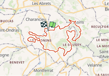
Charancieu

fredkro
User

Length
22 km

Max alt
613 m

Uphill gradient
563 m
Km-Effort
30 km

Min alt
328 m

Downhill gradient
563 m
Boucle
Yes
Creation date :
2025-04-27 07:50:07.0
Updated on :
2025-04-27 13:32:19.896
4h22
Difficulty : Medium

FREE GPS app for hiking
 SityTrail
IGN / Geographical institutes
SityTrail Plus
The world is yours!
About
Trail Horseback riding of 22 km to be discovered at Auvergne-Rhône-Alpes, Isère, Les Abrets en Dauphiné. This trail is proposed by fredkro.

Positioning
Country:
France
Region :
Auvergne-Rhône-Alpes
Department/Province :
Isère
Municipality :
Les Abrets en Dauphiné
Location:
La Bâtie-Divisin
Start:(Dec)
Start:(UTM)
702737 ; 5043627 (31T) N.
Comments