


lac de bellevue Peyrins

meillon
User
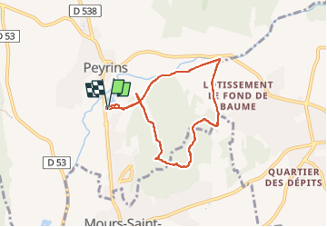

Length
6.6 km

Max alt
292 m

Uphill gradient
123 m
Km-Effort
8.2 km

Min alt
193 m

Downhill gradient
124 m
Boucle
Yes
Creation date :
2025-04-27 12:54:41.216
Updated on :
2025-04-27 15:36:01.647
2h40
Difficulty : Easy

FREE GPS app for hiking
 SityTrail
IGN / Geographical institutes
SityTrail Plus
The world is yours!
About
Trail Walking of 6.6 km to be discovered at Auvergne-Rhône-Alpes, Drôme, Peyrins. This trail is proposed by meillon.
Description
agreable...
Positioning
Country:
France
Region :
Auvergne-Rhône-Alpes
Department/Province :
Drôme
Municipality :
Peyrins
Location:
Unknown
Start:(Dec)
Start:(UTM)
661204 ; 4994619 (31T) N.
Comments