


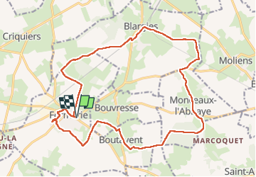
Formerie

jpblimond
User

Length
20 km

Max alt
231 m

Uphill gradient
140 m
Km-Effort
22 km

Min alt
190 m

Downhill gradient
140 m
Boucle
Yes
Creation date :
2025-04-27 11:18:13.0
Updated on :
2025-04-27 16:01:54.268
4h42
Difficulty : Medium

FREE GPS app for hiking
 SityTrail
IGN / Geographical institutes
SityTrail Plus
The world is yours!
About
Trail Walking of 20 km to be discovered at Hauts-de-France, Oise, Formerie. This trail is proposed by jpblimond.
Positioning
Country:
France
Region :
Hauts-de-France
Department/Province :
Oise
Municipality :
Formerie
Location:
Formerie
Start:(Dec)
Start:(UTM)
408675 ; 5500371 (31U) N.
Comments