


Le Sarrier depart La Caire 765+

claude nier
User
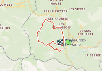

Length
14.1 km

Max alt
1402 m

Uphill gradient
765 m
Km-Effort
24 km

Min alt
997 m

Downhill gradient
764 m
Boucle
Yes
Creation date :
2025-04-27 16:04:35.45
Updated on :
2025-04-27 16:07:14.717
5h30
Difficulty : Medium

FREE GPS app for hiking
 SityTrail
IGN / Geographical institutes
SityTrail Plus
The world is yours!
About
Trail On foot of 14.1 km to be discovered at Auvergne-Rhône-Alpes, Drôme, Lus-la-Croix-Haute. This trail is proposed by claude nier.
Description
petite randosympa beau panorama
Positioning
Country:
France
Region :
Auvergne-Rhône-Alpes
Department/Province :
Drôme
Municipality :
Lus-la-Croix-Haute
Location:
Unknown
Start:(Dec)
Start:(UTM)
713500 ; 4948730 (31T) N.
Comments