


Combe Obscure depart La Jarjatte 446+

claude nier
User
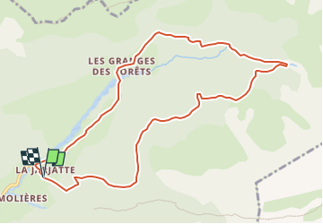

Length
10.9 km

Max alt
1562 m

Uphill gradient
446 m
Km-Effort
16.9 km

Min alt
1149 m

Downhill gradient
455 m
Boucle
Yes
Creation date :
2025-04-27 16:12:59.204
Updated on :
2025-04-27 16:13:50.663
3h49
Difficulty : Easy

FREE GPS app for hiking
 SityTrail
IGN / Geographical institutes
SityTrail Plus
The world is yours!
About
Trail On foot of 10.9 km to be discovered at Auvergne-Rhône-Alpes, Drôme, Lus-la-Croix-Haute. This trail is proposed by claude nier.
Description
rando sympa facile
Positioning
Country:
France
Region :
Auvergne-Rhône-Alpes
Department/Province :
Drôme
Municipality :
Lus-la-Croix-Haute
Location:
Unknown
Start:(Dec)
Start:(UTM)
718579 ; 4950521 (31T) N.
Comments